Land Records
About the Land Records
The first official survey of Florida was performed around 1824. The original survey notes and plats have been preserved and the Florida Department of Environmental Protection has made these General Land Office (GLO) Early Records available to the public in electronic format.
Certified Corner Records have been collected since 1977 and are updated regularly. All records use the recently adopted land identification program sponsored by the Bureau of Land Management.
 |
 |
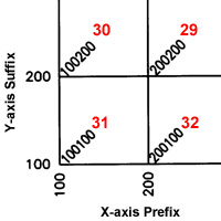
| Explanation of the Florida Public Land Survey System's Unique Identifier Program | Chart overlaying the legacy township descriptors (A01, B13, etc.) with the new BLM Identifiers |
Certified Corner Records
Search by Township/Range or Document Number.
Search Here
Search by Document Number, Township-Range-Section,
or Bureau of Land Management Identifier (BLMID).
Download the CCR Forms
Images for All Documents
The databases associated with CCRs are located in the above section titled "Download the CCR Databases."
The images in this FTP site are electronic copies of the original documents submitted to the Bureau of Survey and Mapping. All Certified Corner document images are available for download.
Images are named by the document number. Leading zeroes are added so that all filenames are of uniform length. Files in PDF format contain all images for a document even if that document has multiple pages.
For example, Document #12345 has two original pages and the electronic document is named 0012345.pdf.
Images prior to #110400 are available in PDF and TIFF format. Documents in TIFF format use one image per page, and the page number is applied to the end of the document number.
For example, Document #12345 has two original pages: Page 1 is named 00123451.tif and Page 2 is 00123452.tif.
The images are organized into three folders:
Information particular to TIFF images
Each image is scanned in TIFF format. Because the scanning process has been ongoing since the 1990s, there are several versions of TIFF that occur throughout this collection. It is possible that certain graphic viewing programs may not be able to read all versions of TIFF. If this happens, try using a different TIFF viewing program.
Viewing Requirements: Any graphics viewing program that can read a TIFF file will work. Many are free of charge.
If you receive a QuickTime error It is because QuickTime has become the default viewer for TIFF and QuickTime is not able to read TIFF files.
Short-term solution:
- bydocno_pdf - Contains a single PDF image identifiable by CCR document number.
- bydocno - Contains images identifiable by CCR document number. Images prior to #110400 are available in TIFF format. These TIFF images have an additional number at the end indicating the page number.
- bycounty - Contains images within counties. This folder will soon contain only single-page PDF images.
Information particular to TIFF images
Each image is scanned in TIFF format. Because the scanning process has been ongoing since the 1990s, there are several versions of TIFF that occur throughout this collection. It is possible that certain graphic viewing programs may not be able to read all versions of TIFF. If this happens, try using a different TIFF viewing program.
Viewing Requirements: Any graphics viewing program that can read a TIFF file will work. Many are free of charge.
If you receive a QuickTime error It is because QuickTime has become the default viewer for TIFF and QuickTime is not able to read TIFF files.
Short-term solution:
- RIGHT-click on the TIFF file and download it to your computer
- Open a TIFF viewer of your choice
- Load the TIFF file that you just downloaded
- Re-associate your web browser to open TIFFs with your software choice
- Re-associate TIFFs for your computer as well
General Land Office (GLO) Early Records
Original survey of Florida from around 1824.
Data consists of the original township plats, surveyor field notes, and original sales plats.
Search by Township/Range or by Volume.
Search by Township/Range or by Volume.
Search Here